


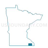
Jordan Twp. Voting District, Fillmore County, Minnesota
About
Outline

Summary
| Unique Area Identifier | 601953 |
| Name | Jordan Twp. Voting District |
| County | Fillmore County |
| State | Minnesota |
| Area (square miles) | 36.02 |
| Land Area (square miles) | 36.02 |
| Water Area (square miles) | 0.00 |
| % of Land Area | 100.00 |
| % of Water Area | 0.00 |
| Latitude of the Internal Point | 43.80429590 |
| Longtitude of the Internal Point | -92.26921540 |
Maps

Graphs
Select a template below for downloading or customizing gragh for Jordan Twp. Voting District, Fillmore County, Minnesota


Neighbors
Neighoring Voting District (by Name) Neighboring Voting District on the Map
- Chatfield Twp. Voting District, Fillmore County, MN
- Fillmore Twp. Voting District, Fillmore County, MN
- Fountain Twp. Voting District, Fillmore County, MN
- Orion Twp. Voting District, Olmsted County, MN
- Pleasant Grove Twp. Voting District, Olmsted County, MN
- Spring Valley Twp. Voting District, Fillmore County, MN
- Sumner Twp. Voting District, Fillmore County, MN
Top 10 Neighboring County Subdivision (by Population) Neighboring County Subdivision on the Map
- Pleasant Grove township, Olmsted County, MN (806)
- Orion township, Olmsted County, MN (592)
- Chatfield township, Fillmore County, MN (531)
- Spring Valley township, Fillmore County, MN (518)
- Sumner township, Fillmore County, MN (458)
- Fillmore township, Fillmore County, MN (457)
- Jordan township, Fillmore County, MN (352)
- Fountain township, Fillmore County, MN (315)
Top 10 Neighboring Unified School District (by Population) Neighboring Unified School District on the Map
Top 10 Neighboring State Legislative District Lower Chamber (by Population) Neighboring State Legislative District Lower Chamber on the Map
- State House District 30B, MN (44,957)
- State House District 27B, MN (37,406)
- State House District 31B, MN (35,692)
Top 10 Neighboring State Legislative District Upper Chamber (by Population) Neighboring State Legislative District Upper Chamber on the Map
- State Senate District 30, MN (83,161)
- State Senate District 31, MN (73,030)
- State Senate District 27, MN (72,647)
Top 10 Neighboring 111th Congressional District (by Population) Neighboring 111th Congressional District on the Map
Top 10 Neighboring Census Tract (by Population) Neighboring Census Tract on the Map
- Census Tract 20, Olmsted County, MN (6,645)
- Census Tract 9602, Fillmore County, MN (4,469)
- Census Tract 22, Olmsted County, MN (3,804)